Welcome to the homepage of Soil Hydrology and Remote Sensing lab at Louisiana State University.
We study the coupled processes in the soil-vegetation-atmospheric continuum to understand scale-specific, emergent soil hydrologic and hydraulic processes under observational and scaling constraints – from point to satellite footprint scale. In short,
Soil | Satellite | Scaling.
Our research centers on soil physics, with a strong emphasis on soil moisture dynamics and hydraulic parameterization. We explore scaling issues in hydrology and leverages satellite remote sensing for large-scale hydroclimatic analysis. Additionally, we provide decision support for real-time flash drought monitoring and forecasting, utilizing advanced hydrological models and remote sensing datasets. Through our research, we aim to improve the understanding and management of water resources, particularly in the context of environmental and agricultural sustainability.

MS/PH.D. POSITIONS AVAILABLE
Highly motivated and qualified students interested in soil physics, hydrological science, and satellite remote-sensing are encouraged to explore our Prospective Students Webpage for details.
Research Highlights
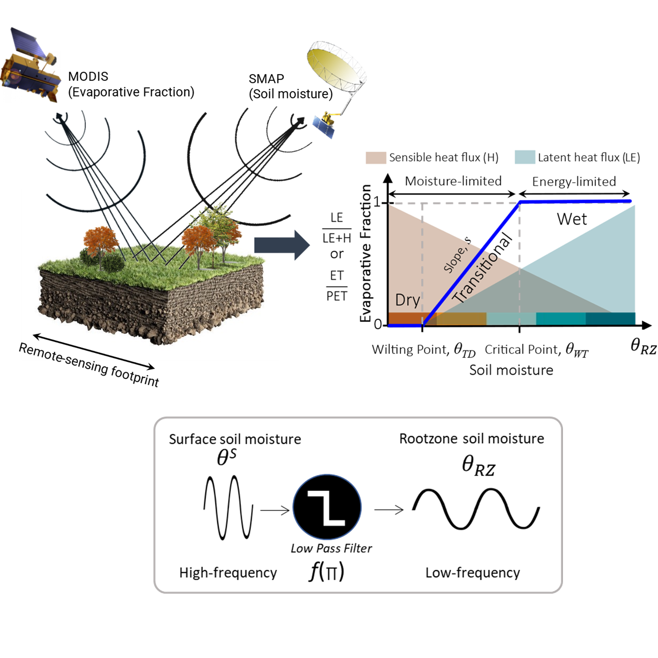
Can we estimate patterns of rootzone soil moisture using land surface fluxes?
New paper in Geophysical Research Letters proposes a method to estimate rootzone soil moisture dynamics on a continental scale. The study proposes using a proxy called the active rootzone degree of saturation, derived by applying recursive low-pass filtering to surface soil moisture observations. This approach is integrated within a terrestrial water-energy coupling and utilizes data from the Soil Moisture Active-Passive (SMAP) satellite and in-situ stations across the contiguous U.S. The results show that the estimated active rootzone degree of saturation aligns well with SMAP Level-4 estimates and in-situ measurements, making it a valuable tool for real-time agricultural drought monitoring.
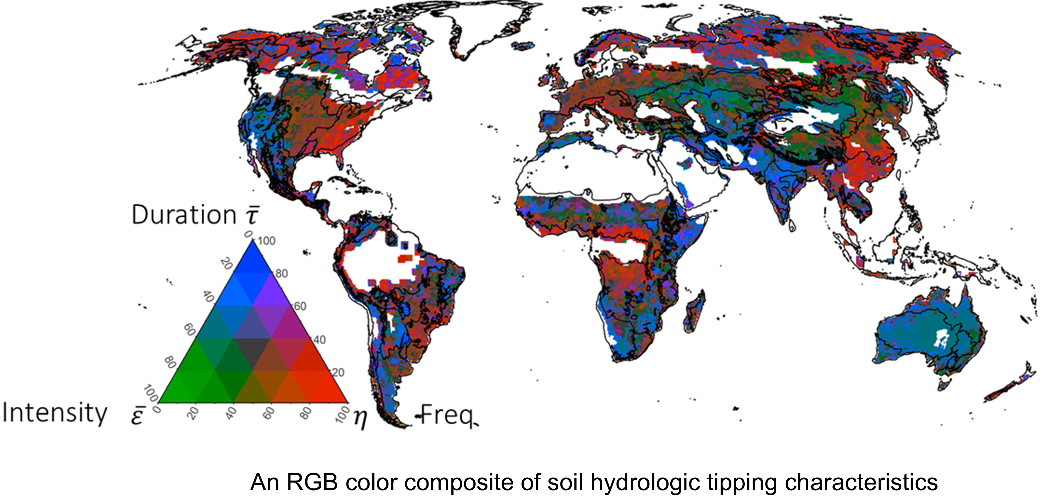
What are the preferential hydrologic states of global surface soil moisture?
Study published in Water Resources Research explores the dynamic behavior of global surface soil moisture using data from NASA’s Soil Moisture Active Passive (SMAP) satellite. It identifies three primary hydrologic states: dry-preferential, wet-preferential, and bistable. The study introduces tipping characteristics to quantify the intensity, frequency, and duration of soil moisture transitions between these states. These characteristics help in understanding soil-vegetation-climate interactions and their sensitivity to climatic changes. The findings highlight the importance of soil moisture dynamics in different biomes and their implications for ecosystem resilience and climate model accuracy¹².
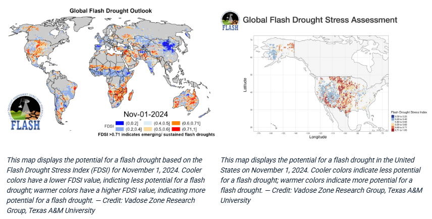
Can SMAP data literally dig up dirt on unexpected droughts?
A National Snow and Ice Data Center newsletter (NSIDC) highlighted our ongoing research on enhanced Flash Drought Monitoring. In collaboration with Texas A&M University and the University of Georgia, we leveraged NASA’s Soil Moisture Active Passive (SMAP) satellite data, archived at NSIDC, to improve drought forecasting by analyzing soil surface moisture trends. By examining SMAP’s soil moisture observations from 2015 to 2021, we developed FLASH (Flash Drought Assessment using SMAP Hydrology), a data visualization tool designed for near real-time soil moisture monitoring. This tool provides early warnings of flash droughts, allowing farmers, water resource managers, and communities to anticipate and respond to sudden drought conditions. With timely insights from FLASH, stakeholders can implement adaptive measures such as adjusting irrigation schedules, adopting alternative seeding methods, managing pest outbreaks, and modifying tillage practices to minimize the adverse effects of flash droughts on agriculture, water resources, and ecosystems.
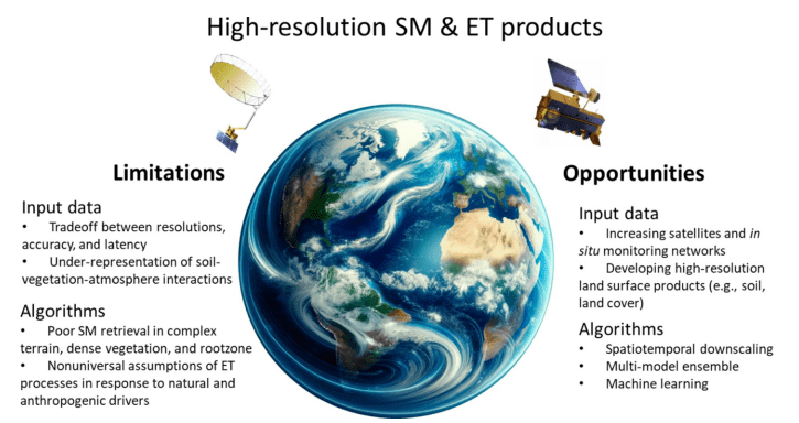
Can High-Resolution Soil Moisture and ET Data Truly Bridge the Science-Society Divide?
A review published in Water Resources Research underscores how high-resolution remote sensing is reshaping our understanding of soil moisture (SM) and evapotranspiration (ET). Recent advances in high-resolution (3–30 m, daily) satellite-based soil moisture (SM) and evapotranspiration (ET) products—enabled by platforms like SMAP, ECOSTRESS, and Hydrosat—offer new opportunities for climate-smart agriculture, water management, and disaster response. Describing the roles of these data in advancing 10 application areas: drought assessment, food security, precision agriculture, soil salinization, wildfire modeling, dust monitoring, flood forecasting, urban water, energy and ecosystem management, ecohydrology, and biodiversity conservation. However, challenges such as reduced accuracy at fine scales, limited rootzone detection, and sparse ground validation limit their practical use. This review calls for integrated efforts in model development, accessibility, and stakeholder engagement to ensure that technological progress translates into tangible societal benefit.
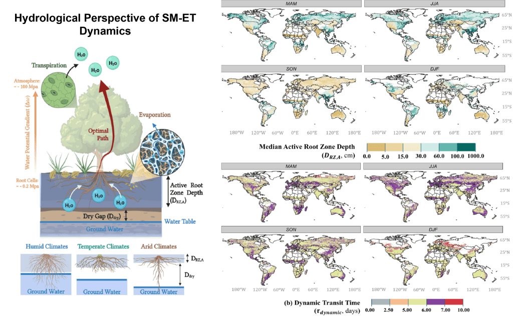
How does soil moisture link to evapotranspiration? A new physics-based approach
A research study published in Water Resources Research introduces a physics-based way to understand how soil moisture drives evapotranspiration by using optimal mass transport theory to trace how water moves from the soil to the atmosphere. By combining satellite soil-moisture drydowns with ET observations, the method quantifies how much water is transferred, how quickly it moves (usually within a few days), and from what effective rootzone depth plants draw during dry periods. This produces clear metrics of SM–ET coupling strength, active rooting depth, and dynamic water-transit times, revealing that ecosystems across climates tend to use water in an efficient “least-action” manner. The framework offers a fresh, physically grounded lens for monitoring drought, understanding plant–water relations, and improving land–atmosphere models.